100 Mile Race Overview
Trail Route will be determined according to weather conditions and is subject to change
Trail Map
Rules 100 Mile
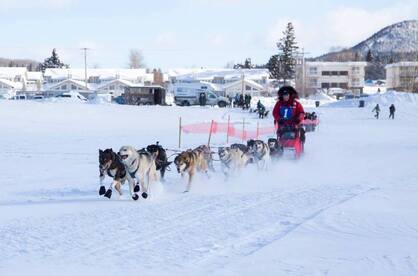
The trail of the 100 mile Caledonia Classic is a trail run on the lake and through a network of bush trails. The race starts in the town of Fort St. James on the shores of Stuart Lake at the famous Cottonwood Beach. Teams leave the starting chute and cross the lake traveling along the shoreline for eight miles passing several homes, a marina and two provincial parks.
After eight miles on the lake teams leave the lake and start in the bush trails. The next 20 miles, teams run northwest paralleling the lake. The trail has rolling hills, narrow sections, bridges and passes through some beautiful Douglas fir stands.
The trail eventually turns to the west and climbs gradually for approximately the next 15 miles. This section of trails is run along old forest service roads and reforested sites. At one point mushers can see three mountain ranges and are in an apex of three watersheds with water flowing north to Mackenzie River, south to the Fraser River system and west into the Skeena River system. This section of trail mushers will also be able to see two First Nations communities: Tache and Binche on the east side of the lake.
Eventually after more ups and downs, mushers will arrive at the “power line” checkpoint. There is no mandatory rest for teams here.
One last big two mile climb and then 13 miles of rolling down hill to the clubhouse.
The checkpoint is at the Snowmobile Club House and has water, 1 bale of straw, and access to their drop bags. Mushers must take a mandatory 8 hour rest here. The checkpoint has vehicle access.
After eight hours of rest teams return past the power line check point and then on a slightly different bush trail back to the lake. After another 8 miles on the lake and a total of 35 miles, teams will arrive at Cottonwood Beach.
Trail Route will be determined according to weather conditions and is subject to change
Trail Map
Rules 100 Mile
The trail of the 100 mile Caledonia Classic is a trail run on the lake and through a network of bush trails. The race starts in the town of Fort St. James on the shores of Stuart Lake at the famous Cottonwood Beach. Teams leave the starting chute and cross the lake traveling along the shoreline for eight miles passing several homes, a marina and two provincial parks.
After eight miles on the lake teams leave the lake and start in the bush trails. The next 20 miles, teams run northwest paralleling the lake. The trail has rolling hills, narrow sections, bridges and passes through some beautiful Douglas fir stands.
The trail eventually turns to the west and climbs gradually for approximately the next 15 miles. This section of trails is run along old forest service roads and reforested sites. At one point mushers can see three mountain ranges and are in an apex of three watersheds with water flowing north to Mackenzie River, south to the Fraser River system and west into the Skeena River system. This section of trail mushers will also be able to see two First Nations communities: Tache and Binche on the east side of the lake.
Eventually after more ups and downs, mushers will arrive at the “power line” checkpoint. There is no mandatory rest for teams here.
One last big two mile climb and then 13 miles of rolling down hill to the clubhouse.
The checkpoint is at the Snowmobile Club House and has water, 1 bale of straw, and access to their drop bags. Mushers must take a mandatory 8 hour rest here. The checkpoint has vehicle access.
After eight hours of rest teams return past the power line check point and then on a slightly different bush trail back to the lake. After another 8 miles on the lake and a total of 35 miles, teams will arrive at Cottonwood Beach.